
The name Dùn Dubh renders from Scottish Gaelic as “the black dun”, and the early 20th-century antiquary Erskine Beveridge counted it among the four fortifications on Coll he found most interesting, alongside Dùn an Achaidh, Dùn Anlaimh and Dùn Morbhaidh. It occupies a rocky ridge near Clabhach on the island’s northern coast, where sheer drops on the west and south left only the eastern flank to be closed off by a succession of stone walls.
Beyond its defences, the fort is bound into a body of Coll tradition: it is remembered as one of three strongholds once held by Norsemen before their defeat by a Maclean chieftain, a story recorded by several ministers and antiquaries between 1895 and the 1920s.
What follows is drawn from published sources, with each claim labelled by how firmly it is established.
The name
Dùn Dubh translates from Scottish Gaelic as "the black dun". The fort carries the grid reference NM18365942 and lies about 620 metres north-north-east of Clabhach.
History
In the early 1900s Erskine Beveridge surveyed and recorded the fort, describing its walls, terraces and enclosures, noting several finds, and judging it to occupy a very strong site because the west and south precipices were inaccessible. He likened its ridge to the one occupied by Dùn Beic.
In 1972 the Ordnance Survey visited and could find no trace of a well Beveridge had reported in a ravine about 30 yards north of the fort, concluding that the only stones in the area came from the fort itself.
The 1976 Ordnance Survey map records a well about 50 metres south-east of the fort, at grid reference NM18415939 — a location distinct from the ravine to the north that Beveridge had described.
People
-
Erskine Beveridge
Early 20th-century antiquary who surveyed the fort, recorded its walls and finds, set its traditions against the documented history of the Macleans, and grouped it among Coll's four most interesting fortifications.
-
Rev. John Gregorson Campbell
Former parish minister of Tiree who collected a Coll tradition mentioning the fort and published it in 1895.
-
Rev. Dugald MacEchern
Author of a 1906 monograph, published in 1922, that acknowledged Beveridge's work and gave a closely similar account naming Dùn Dubh in Grisbol hill.
-
Iain Garbh
Son of Lachlann Bronnach, chief of the Macleans of Duart, and claimed ancestor of the Macleans of Coll; born about 1450, he is central to the traditions of how the island passed to the family.
Cultural influences
-
Stone gathered from the ruins
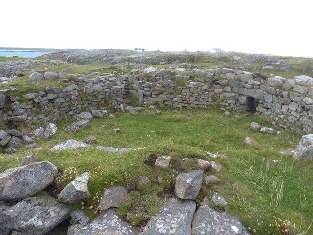
Within the innermost wall stand the remains of two sub-circular enclosures built from stone gathered from the fort's own collapsed defences. The larger measures about 4.6 by 3.7 metres internally and stands roughly 0.5 metres tall; only the foundation of the other survives, a sign the ruined walls were later quarried for smaller structures.
Connections
-
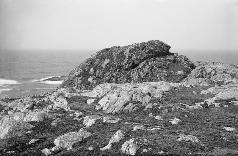
Photo: Erskine Beveridge (1851–1920) / Wikimedia Commons / Public domain Dùn Beic (Totronald)
The fort whose cliff-edge ridge Beveridge compared directly to that of Dùn Dubh; small rounded pebbles found at Dùn Dubh resembled ones recovered from Dùn Beic, and it appears in the same body of tradition.
-
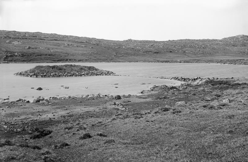
Photo: Erskine Beveridge (1851–1920) / Wikimedia Commons / Public domain Dùn Anlaimh
The island-fort in Loch nan Cinneachan associated with the Norse chief Annla Mòr; the pack lists it as one of the duns linked with Dùn Dubh in Coll tradition.
-
Dùn an Achaidh and Dùn Morbhaidh
The two remaining fortifications Beveridge placed with Dùn Dubh and Dùn Anlaimh among the four most interesting on the island.
Discovery & excavation
The fort was documented by the antiquarian Erskine Beveridge in the early 20th century (published 1903); his survey recorded the walls, terraces and sub-circular enclosures and reported several finds — hammerstones, fragments of coarse pottery, and small rounded pebbles resembling those from Dùn Beic. The Ordnance Survey revisited the site in 1972.
In culture
-
Recorded in the antiquarian literature
Dùn Dubh appears across the late 19th- and early 20th-century writing on Coll's forts, duns and crannogs — Campbell's collected tradition of 1895, Beveridge's account of 1903, and MacEchern's monograph of 1906. Each frames the fort within the same cluster of island strongholds and the story of how the Macleans came to hold Coll.
What to look for
-
The ridge and its boss
The fort sits on a rocky ridge running north-west to south-east, with a high rocky boss at the south-east end and terraces to the north-west that drop steeply on the west and almost vertically on the south.
-
Wall A along the crest
The innermost wall runs along the crest, standing about 0.3 metres in two courses, though its inner core reaches roughly 1 metre high. The two sub-circular enclosures lie within it.
-
The outer eastern walls
About 2.5 metres down the slope, wall B stands about 1 metre in four courses. The north-east flank is defended by a further wall reaching 1.2 metres in six courses where best preserved, one northern stretch of which seals a narrow gully.
What is said
Folklore and tradition, recorded as what is said — not as established fact.
-
A Norse stronghold taken by the Macleans
It is said that Dùn Dubh was one of three Coll forts held by Norsemen — three brothers from Lochlin — until the Laird of Duart, told by a woman at Caolas that he was unworthy of provisions while he allowed Norsemen to keep the island, moved against them; the decisive fight is placed at Grimsary. (unverified local tradition)
-
The disputed date of 1384
One version, taken down viva voce by Beveridge in 1903, dated the events to 1384. Beveridge conceded the date was merely back-calculated from a belief that the Macleans had held Coll for exactly 472 years when they sold the estate in 1854, and noted the earliest documentary link between a Maclean and Coll is a 1495 charter referring to a grant of 1409. (unverified)
-
A possible confusion with the MacNeils
Beveridge recorded a further tradition of a battle near Grishipol, around 1470–1480, in which Iain Garbh defeated a force led by his step-father Gilleonan, chief of the MacNeils of Barra, and wondered whether the Norsemen story might confuse that later conflict. (unverified)
Plan your visit
- Location
- 56.6416°N · 6.5955°W
- Access
- Open access
- Terrain
- Moderate walking
Nearby places
Questions people ask
- What does the name Dùn Dubh mean?
- It translates from Scottish Gaelic as "the black dun".
- Where is Dùn Dubh?
- On a rocky ridge on the northern coast of the Inner Hebridean island of Coll, about 620 metres north-north-east of Clabhach, at grid reference NM18365942.
- What archaeological finds have come from the fort?
- Beveridge recorded hammerstones, fragments of coarse pottery, and small rounded pebbles similar to ones found at the nearby fort of Dùn Beic.
- Why is the fort tied to a story about Norsemen?
- A local Coll tradition holds that Dùn Dubh was one of three forts held by Norsemen before they were defeated by a Maclean chieftain. It is unverified tradition; Beveridge himself questioned the date attached to it and suspected a possible confusion with a later Maclean battle against the MacNeils of Barra.
- Is there a well at the site?
- Beveridge described a possible well in a ravine to the north, but the Ordnance Survey found no trace of it in 1972. The 1976 OS map instead marks a well about 50 metres south-east of the fort.
Sources
- Wikipedia: Dùn Dubh (accessed 2026-07-18)
- Wikidata: Dùn Dubh (Q5320408) (accessed 2026-07-18)
Explore more: Fortified places · Iron Age · Argyll and Bute
The Ancient Codex, in your pocket
Get the Pocket Codex app
Carry the directory with you — Dùn Dubh and thousands of ancient places across Britain and Ireland, offline, wherever you roam.